Severe Flash Floods Ban Rong Pua Following Heavy Rain Near Doi Phu Kha

Md.Moshail Ahmed
August 19, 2026
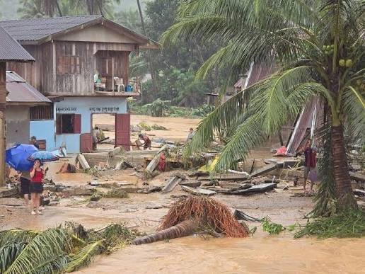
On Thursday, August 20, 2026, emergency response teams reported that flash floods Ban Rong Pua rescue operations remain active across Nan province after torrential downpours devastated northern Thailand. Specifically, rainfall exceeding 110 millimeters at the Doi Phu Kha National Park office triggered rapid runoff early Wednesday, inundating residential neighborhoods and severing major transit corridors. In addition, the Department of Disaster Prevention and Mitigation (DDPM) issued an “Extreme Alert” via Cell Broadcast to mobile phones across Pua district, urging residents to relocate belongings and vulnerable individuals immediately. Readers can also track real-time weather updates on our Thailand emergency tracking portal.
Upstream Deluge Triggers Severe Flash Floods Ban Rong Pua
In fact, Ban Rong in Pua subdistrict was among the hardest-hit areas as floodwaters surged up to second-storey levels in several structures. Furthermore, reporting from The Star confirms that over 8,000 families across 60 villages in Pua district have been affected by overflowing waterways. Consequently, local authorities deployed motorboats and rescue crews to evacuate residents trapped inside inundated homes. Meanwhile, severe landslides and collapsed bridges along Highway 1256 completely cut off direct access to Bo Kluea district. For regional weather analysis, explore our Asia weather archive.
Disaster Pipeline & Emergency Action Sequence
(Chronological breakdown of the Nan province flash flood crisis)
↓
Overnight Downpours Near Doi Phu Kha (Aug 19, 2026)
(Over 110mm–200mm of torrential rain falls in the forested headwater region)
↓
Sudden Forest Runoff & River Overflows
(Rapid currents inundate Ban Rong, Ban Na Lae, and neighboring subdistricts)
↓
Bridge Collapses & Highway Closures
(Key bridges wash away; Highway 101, 1256, and 1371 are closed to all traffic)
↓
Cell Broadcast Alert & Relief Deployments
(DDPM issues emergency warnings while rescue boats deploy to evacuate residents)
“Pua district continues to experience heavy rain, with the risk of flash floods, overflowing waterways and landslides. Residents should immediately move belongings to higher ground.”
— Department of Disaster Prevention and Mitigation (DDPM), Emergency Cell Broadcast Warning
Transportation Breakdown and Relief Operations
Indeed, transportation networks across Nan province suffered severe disruptions due to structural bridge washouts and mudslides. For instance, detailed survey reports from Nation Thailand confirm that Nan Highway District 2 officially closed three major highway points to traffic. Moreover, disaster response personnel set up emergency shelters to distribute clean drinking water, food supplies, and medical assistance. Therefore, officials advise travelers heading toward Pua and Bo Kluea to avoid flooded routes. Ultimately, provincial agencies remain on high alert as water levels in the Yao and Wa rivers continue rising.
| Disaster Parameter / Metric | Official Status & Impact Details |
| Focus Keyword | Flash Floods Ban Rong Pua. |
| Primary Location | Ban Rong, Pua District, Nan Province, Thailand. |
| Rainfall Volume | Exceeded 110 mm–200 mm overnight near Doi Phu Kha. |
| Impacted Population | ~8,000 families across 60 villages in Pua district. |
| Highway Closures | Highway 101, Highway 1256 (bridge collapsed), Highway 1371. |
| Emergency Protocol | Extreme Cell Broadcast alert issued by DDPM. |
Sources
- Nation Thailand – Flash floods cut major roads and inundate homes across Nan’s Pua
- The Star – Flash floods cut major roads and inundate homes in northern Thailand
- Thai PBS World – Flash floods inundate Nan province, cutting off key routes and bridges
- Khaosod English – Heavy rain floods Nan, damages weir and collapses bridge on key route



More